
shafaghmotevalli - alireza mahyari
Tehran Number By Number
This article was written on November 3, 2019, following a call for a book about the Rudaki region, but it seems that the book was never published.
Abstract
The Roudaki Zone is an area that, in the current year, has been introduced as a zone where—through cooperation between the City Council and Tehran Municipality—the conditions for the presence and activities of artists will be facilitated. Alongside this, efforts have also been envisioned to revitalize the book market.
The present article examines the upper-level planning documents related to this zone as well as the historical background of its location. This review seeks, insofar as access to sources allows, to identify and introduce the tangible and intangible physical values of the area. In doing so, it aims not only to highlight the latent potentials for sustainable development, but also to take a step toward completing the information database of the area under discussion.
Zones such as the Roudaki Cultural Zone, more than any other intervention, require the organization of an information database that is continuously updated and easily accessible to research groups in urban studies and ethnography, as well as to designers of tourism routes.
Keywords
Roudaki Zone; New Activity Areas of Tehran; Culture and Music Zone
Introduction
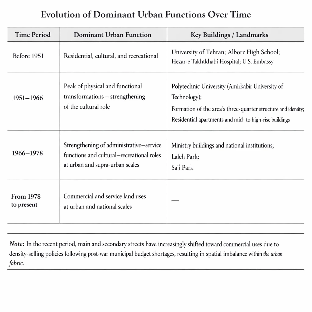
After experiencing its first fortification walls during the reign of Shah Tahmasp, Tehran went through two major phases of urban expansion. The first followed the demolition of the Safavid walls and resulted in what became known as Naseri Tehran; the second followed the demolition of the Naseri walls and led to the Pahlavi (Reza Shah) expansion in the early decades of the present century.
The Reza Shah–era development was not merely the destruction of earlier ramparts and fortifications; it was a form of development that, in response to prevailing conditions, needs, and policies, brought about fundamental changes in ways of life. New professions emerged, Western-educated graduates returning from Europe began to practice as a professional expert class, art became more accessible to the general public, and social life gradually shifted from private interiors, bathhouses, and alleys to streets, cafés, cinemas, and other public venues.
The Roudaki Cultural Zone is an area at the heart of modernizing Tehran that accommodates performing arts and musical activities. This article examines the process of formation of this zone through the study of urban documents and plans.
The Roudaki Zone in Upper-Level Planning Documents
The subject area of this article is the Roudaki Cultural Zone. The defined boundaries of the Roudaki Zone extend from Enghelab Street to the north, Nofel Le Château Street to the south, Hafez Street to the east, and Valiasr Street to the west. In effect, it is located at the core of Tehran’s New Activity Center (the University of Tehran area), a fact that in itself confirms the significance of this zone.
The University Area (the New Activity Center of Tehran), according to the approved 2007 Tehran Comprehensive Plan, has been identified as one of the city’s seven main centers, with an emphasis on cultural and academic activities. In addition to this, its central axis—Enghelab Street—has historically served as a major site for social and political gatherings and demonstrations. It also carries the collective memory of Tehran’s transition: from the Qajar period to the south of the axis, and the beginning of modern Tehran to the north.
Accordingly, this study first examines the approved 2007 Comprehensive Plan of Tehran and the New Activity Center, followed by an overview of the municipal districts encompassed within this area.
In the vision of the 2007 Tehran Comprehensive Plan, Tehran is envisioned as a metropolis with national and global functions, serving as the political, cultural, social, and economic center of the country, the Southwest Asia region, and the Islamic world.
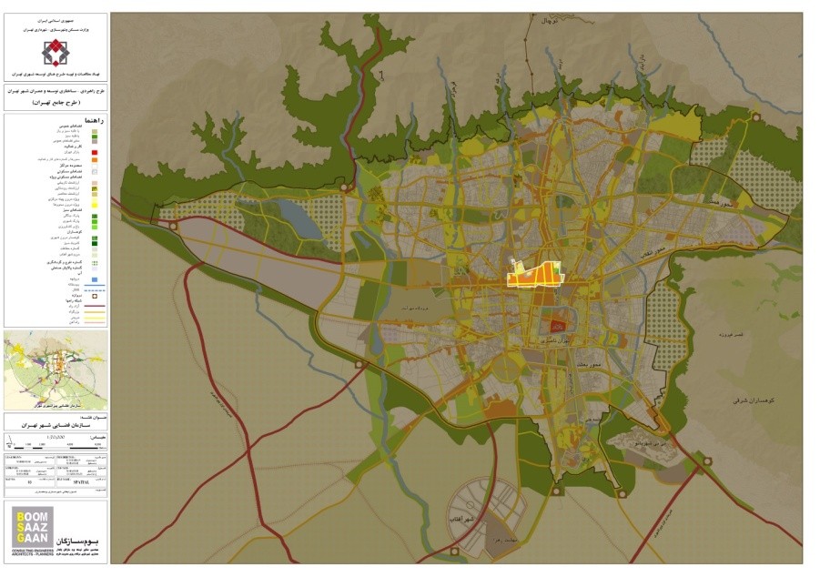
Location of the area in the master plan, source: (Tehran Municipality 2007)
The area of modern activities in Tehran is located to the north of Karimkhan Zand Street and Keshavarz Boulevard, to the south of Jomhuri Street, on the eastern borders of Mofateh and Bahar Streets, and on the western border of Doctor Gharib and Avesta Streets.
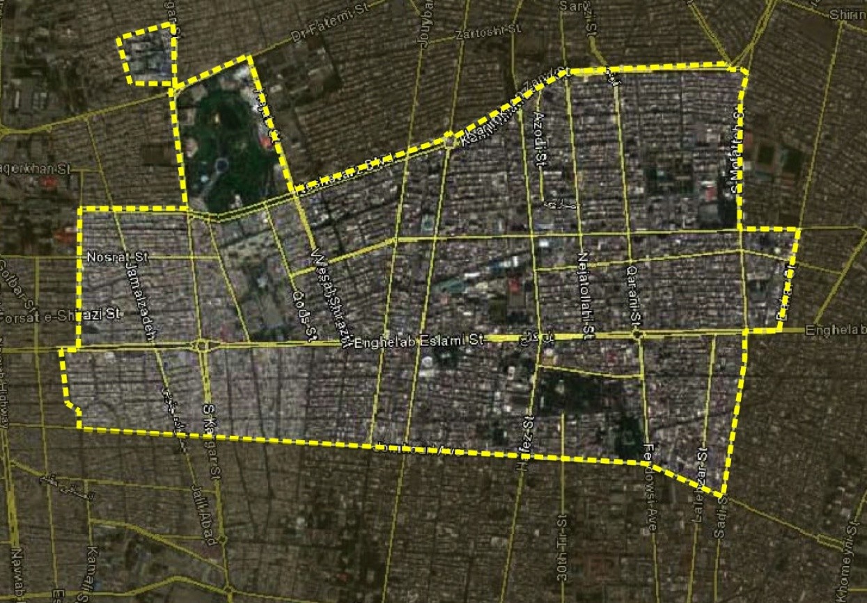
Tehran's New Activities Area, Source: (Motevalli 2015)
The main emphasis of the Comprehensive Plan in the aforementioned zone is on academic spaces such as the University of Tehran, Amirkabir University of Technology, the University of Art, and the Architecture Faculty of Islamic Azad University, as well as on artistic venues in the area, including City Theater, Vahdat Hall, Farhang Hall, and the printing, publishing, and book distribution center located opposite the University of Tehran. In fact, the Comprehensive Plan has identified this zone as the cultural center and the hub of Tehran’s new economic activities, relying precisely on these cultural, academic, and artistic functions.
Within the Comprehensive Plan, the campus of the University of Tehran—due to its historical background and its role in the emergence of academic education during Iran’s modernization period, as well as its developmental impacts such as the formation of bookshop corridors and the establishment of other universities—has been designated as the Historic Campus of the University of Tehran.
Moreover, the Comprehensive Plan emphasizes the memorial and symbolic value of this zone as a setting for historical gatherings and political demonstrations. Accordingly, the plan recommends the establishment and reinforcement of knowledge- and culture-related activities within this area (Tarh va Me‘mari, 2013, p. 22).
Another aspect highlighted by the Comprehensive Plan regarding the University Area is the need to address the main axis through two distinct approaches in urban organization. In planning and reorganization schemes, the northern side of Enghelab Street is considered representative of modern Tehran, while its southern side is regarded as historical Tehran (Me‘mari, 2013, p. 23).
The Damavand–Enghelab–Azadi axis occupies a distinctive position in the physical structure of Tehran as a connective element linking five north–south axes. Through appropriate organization, it can function as the Memory Axis of Tehran, situated between historical Tehran (south of Enghelab Street) and modern Tehran (north of Enghelab Street). In this way, its multiple conceptual dimensions may be embodied within the city’s physical form, becoming an identity-defining element for Tehran—more tangibly than at present, although it already serves such a role (Me‘mari, 2013, p. 2).
Introducing the Area from the Perspective of Comprehensive Plan Documents
As illustrated in the relevant figures, this area has consistently held a special position in urban planning documents.
In the 1967 Comprehensive Plan, the area was identified as one of the zones of importance in Tehran’s east–west expansion, a trend that can also be observed in the ATK Urban Plan (1992). The approved 2007 Comprehensive Plan—which remains the most recent comprehensive plan for Tehran to date (as of 2019)—has likewise adopted the same approach, as previously noted.
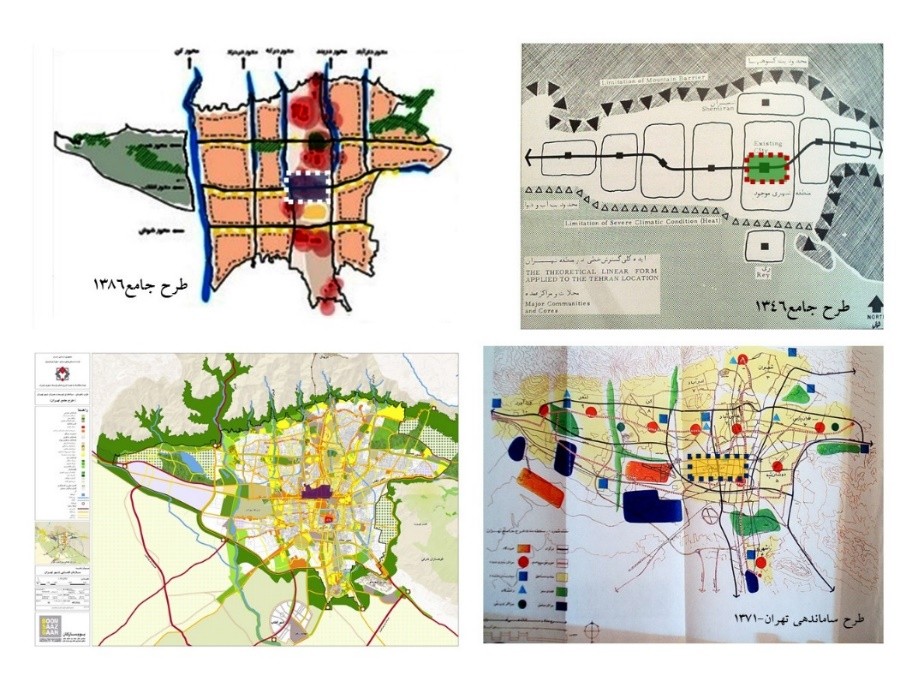
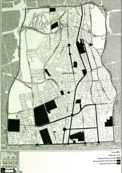
Historical study of the area in urban plans, source: (Deputy Technical and Civil Engineering Office of Tehran Municipality, The Skeleton of Tehran City, Volume 2, 1997)
This center is internally divided into the following sub-areas:
- Visual Arts Zone: Laleh Park;
- Scientific–Cultural Axis: Dowlat Gate – Enghelab Square;
- Roudaki Neighborhood: Tehran’s music and performing arts zone;
- National and Antique Arts Zone (Villa, Ferdowsi, Taleghani, Somayeh, Arbāb Jamshid, Manouchehri): revitalization of the Lalehzar axis;
- Si-Tir Street: a ceremonial and ritual street (located within the zone of influence) (Assarzadeh, 2013, p. 95).
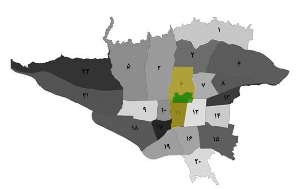
Location of "Tehran's New Activities Area" in the Municipality's Zoning, (Motavali 2015)
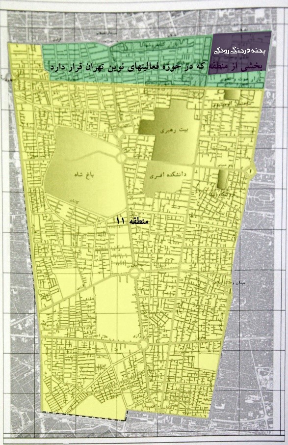
This center is located in the northern part of the municipality in District 6 and in the southern part in District 11.
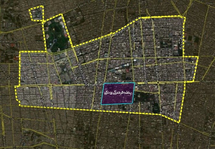
Rudaki Cultural Zone Area
The Roudaki Cultural Zone is located within the New Activity Area of Tehran in Municipal District 11. Nevertheless, in addition to examining District 11, it is necessary to review the potentials of District 6, which lies to the north of the zone and is directly adjacent to the Roudaki Zone. This is because human social interactions and urban mechanisms are not confined to administratively defined boundaries.
Key Land Uses
District 6, in terms of its historical background and its significance in the collective memory of residents and users, encompasses several important historical zones and axes, the most significant of which are illustrated in the following map.
Moreover, the number of valuable buildings within the district amounts to approximately 80 structures. Of these, only 11 buildings and sites are currently registered on Iran’s National Heritage List. These eleven registered properties include: the University of Tehran, the Tehran Museum of Contemporary Art, Shafagh Park, Imam Khomeini Hospital, the Blood Transfusion Center, Anoushirvan High School, Alborz High School, Dr. Shariati’s House, Mohammad-Ali Sepanlou’s House, Mehdi Akhavan-Sales’ House, and the former University of Tehran Kindergarten (Farhangi, 2007, p. 39).
Among these, only Shafagh Park and the house of Mehdi Akhavan-Sales are located outside the New Activity Area of Tehran, while Imam Khomeini Hospital falls within its zone of influence
The most important historical axes and areas of Region 6, Source: Comprehensive Plan for the Development of Cultural Spaces, 39, 2007
A brief historical overview of the region, source: Archives of the Contemporary Iranian Architecture Workshop
District 11
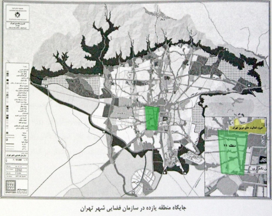
The position of District 11 in the spatial organization of Tehran, Motevalli 2015)
Major Land Uses and Dominant Activities
At the district scale, a wide range of highly significant land uses and activities are concentrated in the area. These include major political and governmental centers with national and supra-national functions, such as the Office of the Supreme Leader, the Presidential Complex, the Expediency Discernment Council, and the Judiciary.
In addition, the area accommodates specialized markets with supra-regional and citywide influence, including centers for garment production and sales, tool and equipment markets, book publishing and distribution centers, bookstores, automotive parts sales and repair workshops, and audio-visual equipment markets.
The presence of large-scale industrial facilities, such as the Tobacco Factory, along with special and restricted land uses—including military complexes, the War College, the Army Officer Training Academy, and the Army Faculty of Veterinary Medicine—further contributes to the functional diversity of the area.
The district also hosts specialized healthcare centers with supra-regional importance, such as Roozbeh Hospital and Farabi Hospital, alongside the most important venues for music and performing arts in Tehran, notably the City Theater Complex and Rudaki (Vahdat) Hall. These major cultural institutions are located adjacent to a broad spectrum of residential fabrics, each with distinct physical and morphological characteristics.
The functional weight and institutional authority of each of these activities are such that no single dominant or one-dimensional role can be attributed to the area. Instead, the district should be understood as a multi-functional and complex urban zone, shaped by the coexistence and interaction of political, cultural, economic, industrial, medical, military, and residential uses (Farhangi, 2007, p. 51).
District 11, (Administrator 2015)
Historic and Heritage Assets of the Area
A number of registered historical monuments, as well as buildings that have been identified by the district consultant as historically valuable and proposed for heritage registration, are listed below.
Registered Historic Buildings
- Sheikh Hadi Mausoleum
- Giv Mansion
- Anis al-Dowleh House
Historic Buildings Proposed for Registration by the Consultant
- Tootonchi Mosque
- Shah Garden (Har Garrison)
- War College
- Officer Training Academy
- Former Gendarmerie Building
- National Bank of Iran Building
- Niagara Cinema
- Loghman al-Dowleh House
- Mossadegh House
- Music Conservatory
- “Little Shahrivar” (Shahriar) House
- Firuzkuhi School
- Ayatollah Kashani School
- Vatican Embassy
- Institute of Philosophy and Wisdom (Iranian Institute of Philosophy)
- Daneshjoo Park
- Vahdat (Rudaki) Hall
- Endowments and Charity Affairs Organization (Awqaf Organization)
- Embassy of Italy
- Azari Traditional Restaurant (Sofreh Khaneh Azari)
- Embassy of France
- Armenian Embassy Building
- Armenian Club
In addition to the above, the consultant has identified 197 residential houses and 25 public buildings as possessing significant historical and cultural value, warranting protection and potential registration (Farhangi, 2007, p. 53).
A brief historical overview of the region, source: Archives of the Contemporary Iranian Architecture Workshop
Proposed Conceptual Development Patterns in the Area
Rudaki Neighborhood: Music and Performing Arts Zone
This area, by accommodating cultural and artistic functions at supra-regional and citywide scales, is identified as the Music and Performing Arts Zone. Key institutions located within this zone include:
- City Theater Complex: the most active and influential theater center in Iran
- Vahdat Hall (Rudaki Hall): the most active center for music performances in the country
- Farhang Hall: the oldest music performance venue in Iran
The scale and significance of these functions—extending beyond the regional level to citywide and even supra-city scales—together with the zone’s location adjacent to major educational and academic land uses north of Enghelab Street (including the University of Tehran, Alborz High School, Tehran Polytechnic [Amirkabir University of Technology], and the University of Art), as well as the bookstore and publishing corridor south of Enghelab Street, demonstrate the area’s exceptional potential for attracting cultural and art-oriented audiences.
This unique spatial convergence of performing arts institutions, academic centers, and cultural-commercial activities underscores the necessity of focused planning intervention, protection, and reinforcement of the cultural–artistic activities established within the Rudaki Neighborhood. Strengthening this zone is therefore essential to consolidating its role as a core cultural hub within the Pehne-ye Farhangi-ye Rudaki and the broader center of modern Tehran’s activities (Haeri, 2015).
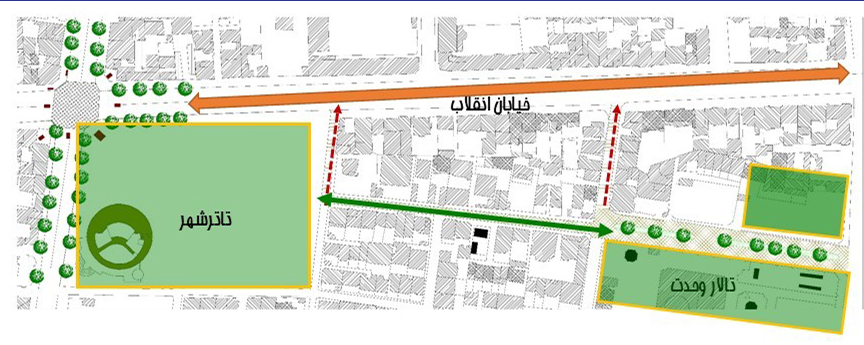
Image 9 - Music and Performing Arts Area, Source: (Motevalli 2015)
Scientific–Cultural Axis: Dowlat Gate – Enghelab Square
This axis can be clearly identified as extending from Dowlat Gate in the east to Enghelab Square in the west. Along its peripheral edges, it accommodates a high concentration of higher-education institutions, including Tarbiat Modares University, Amirkabir University of Technology, the University of Art, the Faculty of Veterinary Medicine, the historic Alborz High School, and many other academic institutions.
In addition to these educational facilities, the axis hosts a wide range of scientific, cultural, and artistic activities, such as cinemas, Daneshjoo Park, the City Theater Complex, long-established and contemporary printing and publishing institutions, as well as the highest concentration of bookstores and general and specialized educational centers. To date, nowhere else in the history of Tehran—or Iran—has such a diverse set of knowledge-based, cultural, and artistic functions operated side by side within a linear urban corridor, forming a large-scale functional network of mutual adjacency and interaction.
The importance of this axis, more than any other factor, is fundamentally linked to the historical presence of the University of Tehran. On the one hand, the university represents the origins and evolution of academic knowledge and modern education during Iran’s modernization period; on the other hand, it reflects the linear spatial expansion of knowledge-based development along a major urban axis. From this perspective, the Dowlat Gate–Enghelab axis can be regarded as the largest integrated axis of knowledge, culture, and art in modern Iran, possessing exceptional historical and cultural significance.
In the New Comprehensive Plan of Tehran, Enghelab Street and its surrounding blocks are designated as part of the Scientific–Cultural Center of New Urban Activities, identified as one of the proposed major centers of the city. Similarly, in the development framework of District 6, functional and physical reorganization of the Enghelab axis—specifically the segment between the Faculty of Veterinary Medicine and Tarbiat Modares University—has been emphasized. This reorganization focuses on strengthening and upgrading cultural and educational activities, restoration and physical improvement of the urban fabric, and the organization of pedestrian and vehicular movement (Farhangi, 2007, p. 63).
It is noteworthy that both planning frameworks, as discussed above, are situated within the New Activity Areas of Tehran. The Rudaki Cultural Zone, which constitutes the main subject of this study, and the Dowlat Gate–Enghelab cultural axis are both part of the spatial extent and the zone of influence of the Rudaki Zone, reinforcing its role as a central cultural–academic core within modern Tehran.
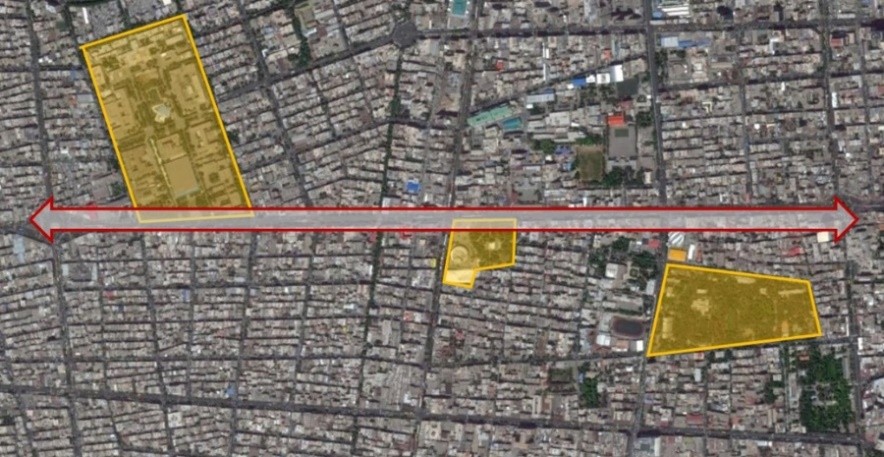
Enghelab axis, source: (Motevalli 2015)
Antique and Performing Arts Zone
Among the pioneering proposals of the Tehran Cultural Development Comprehensive Plan is the Antique and Performing Arts Zone. Although, according to the municipal administrative division, this zone is located within District 12 of Tehran Municipality, it is fully situated within the area of study and influence of the present research.
Comprehensive Plan for the Development of Cultural Spaces
In 2007, the Cultural Spaces Development Company prepared and presented a guiding document entitled “Comprehensive Plan for the Development of Cultural Spaces: Model and Leading Projects of Tehran”. Based on the cultural and event-oriented potentials of different urban areas, this document identified a series of related cultural zones, the most relevant of which to this study are discussed below.
Visual Arts Cultural Zone: Laleh Park
This cultural zone is located between Saba Street, Palestine Street, Vesal Street, and Kargar Street. The adjacency of this area to three urban and supra-urban functional zones—including:
- the Center of New Urban Activities (as designated in the New Comprehensive Plan of Tehran),
- the cultural development project of the Rudaki Neighborhood (Tehran’s Performing Arts and Music Zone),
- and the Scientific–Cultural Axis of Dowlat Gate–Enghelab Square, proposed as a model project in the Cultural Spaces Comprehensive Plan—
constitutes a major potential and capacity for the development of cultural spaces in this area (Farhangi, 2007, p. 40).
Historically, this zone has played a significant role in contemporary cultural events, including the emergence of modern cinemas, the establishment of valuable museums, active art galleries, influential educational institutions, as well as major social events and popular movements.
Cultural and Social Significance of Laleh Park
The importance of this zone is strongly linked to the presence of Laleh Park, one of Tehran’s oldest parks, formerly known as Jalalieh Park. The park accommodates several high-value cultural institutions, including:
- the Carpet Museum of Iran,
- the Tehran Museum of Contemporary Art,
- and the Institute for the Intellectual Development of Children and Young Adults.
Historically, Laleh Park has hosted numerous social and cultural events, such as garden parties, parachuting demonstrations, the introduction of the first electric vehicle, and the first circus performances in Tehran. This strong social character has been preserved to the present day, as the park continues to function as a vibrant and active cultural–social space.
Cultural Facilities and Urban Memory
Other cultural activities within this zone include several highly active, city-scale galleries, such as Khial Gallery, Tehran Gallery, Laleh Gallery, the Saba Cultural Complex, the Academy of Arts, Small Theater (Teatr-e Kuchak), the Chess House, and Palestine Cinema, which once featured the largest balcony of its time. Additional landmarks include Qiyam Cinema, Radio City Cinema, and many other significant cultural spaces—some of which still exist, while others survive as part of the city’s collective urban memory (Farhangi, 2007, p. 41).
Asr-e Jadid Cinema, notable for its architectural value, together with Farhang Cinema, once served as an important social hub for audiences interested in art-house and alternative films. Boulevard Cinema, formerly dedicated to children’s films, is also located within this area. Moreover, a residential building designed by a renowned late Armenian architect has recently been acquired by the Ministry of Roads and Urban Development and is planned to be transformed into the House of Urban Discourse.
The zone also contains valuable historical–social buildings, such as the Iran–Russia Association, designed by the prominent architect Markov, and the Tehran Museum of Contemporary Art, which is recognized as a building of outstanding architectural significance. In addition, prominent social figures have been historically associated with this area, including Dr. Gharib, a distinguished physician and author of numerous medical works (Farhangi, 2007, p. 41).
Conclusion
Sustainable development is a comprehensive and multidimensional concept that has gained increasing importance in recent decades due to the depletion of natural resources. It seeks to improve quality of life by emphasizing the effective use of existing local assets. This approach encompasses a wide range of cultural, social, and environmental dimensions, all of which require a thorough understanding of the local context as a fundamental prerequisite.
The Center of New Urban Activities of Tehran, in addition to hosting diverse social groups, represents one of the city’s most important areas for contemporary architectural heritage and national-scale social and artistic events. Within this framework, the Rudaki Cultural Zone functions as the artistic core of this area.
Currently, 35 heritage-value residential buildings have been identified within the Rudaki Zone. Undoubtedly, many additional potentials and cultural events remain to be revealed through further research and focused planning efforts. The accumulation of physical, cultural, and event-based values constitutes a form of social capital that directly influences everyday urban life and can act as a key catalyst for sustainable development in the area.
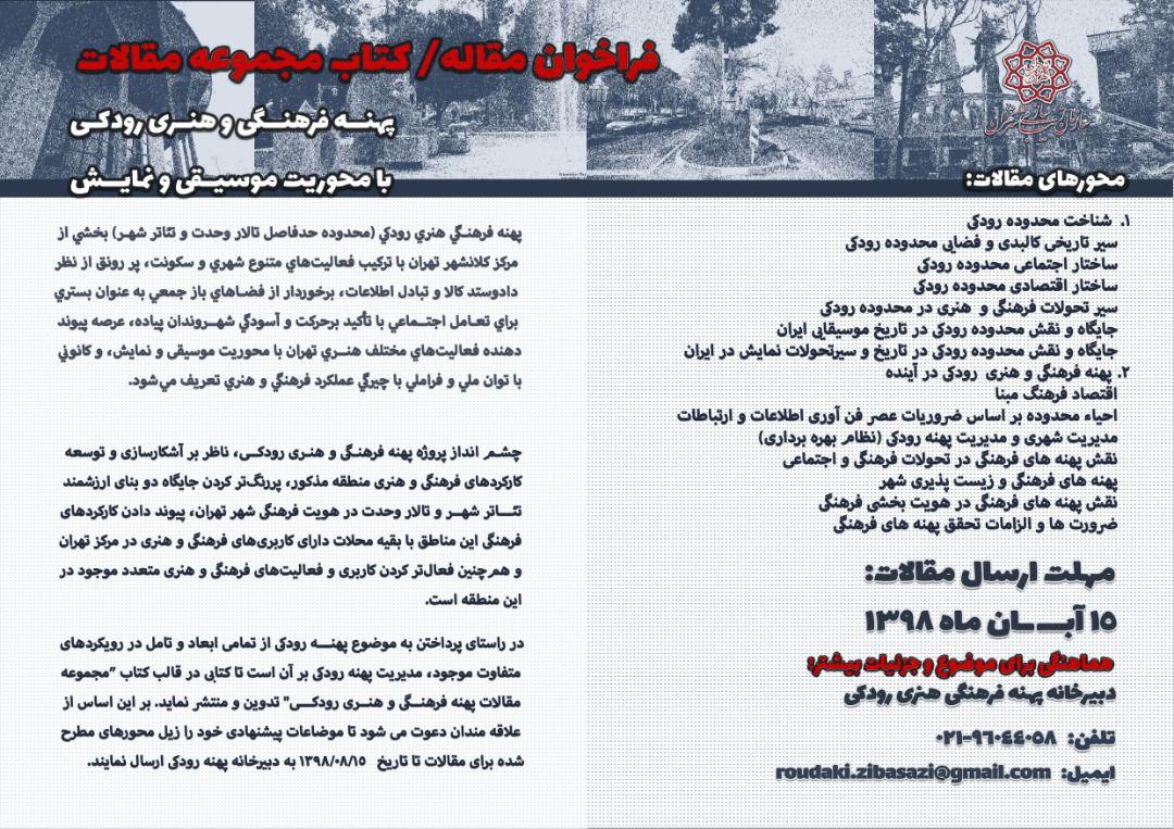
Call for submissions
References
Tahamy, D., & Abrishami, V. (2006). A Passage through Tehran: Photographs of a Century of Tehran (1250–1350 SH). Tehran: Mirdashti.
Haeri, M. (2015). Archive of the Iranian Contemporary Architecture Workshop (ICAW). Tehran.
Habibi, S., & Bidehendi, S. (2012). The Story of the City: Tehran as a Symbol of Iranian Modern Urbanism, with Emphasis on 1299–1332 SH (2nd ed.). Tehran: University of Tehran Press.
Tehran Beautification Organization. (2018). Introduction to the Rudaki Zone. Proceedings of the 4th National Festival of Creative Circle Urban Furniture Design, 1.
Shafigh, M. (n.d.). Two Dialogue Sessions with Masoud Shafigh. Iranian Alumni of Italy Association. Tehran: New Iranian Architecture Scientific Association; Faza Scientific and Cultural Institute; Dr. Flamaki Architecture Institute.
Tehran Municipality. (2007). Tehran Comprehensive Plan Document. Tehran: Tehran Municipality.
Tarh va Me‘mari Consulting Engineers. (2013). Urban Design Framework Study Reports: University Area. Tehran: Tehran Municipality Beautification Organization.
Tahamy, D., & Haddadi, V. (2012). Come with Me to Tehran. Tehran: Gooya Cultural House.
Assarzadeh, A. (2013). Evaluation of Creative City Indicators in the Cultural Zone. Tehran: Islamic Azad University, Central Tehran Branch.
Farhangi, S. T. (2007). Comprehensive Plan for the Development of Cultural Spaces in Tehran: Model and Leading Projects – Appendix 1: Base Guidance Document. Tehran: Tehran Municipality Cultural Spaces Development Company.
Motavalli, S. (2015). Re-Recognizing the City with Emphasis on the Behavioral Pattern of the Flâneur. Tehran: Islamic Azad University, Central Tehran Branch.
Tehran Municipality, Technical and Civil Deputy. (1997). The Structural Framework of Tehran City (Vol. 1). Tehran: Technical and Civil Deputy of Tehran Municipality.
Tehran Municipality, Technical and Civil Deputy. (1997). The Structural Framework of Tehran City (Vol. 2). Tehran: Tehran Municipality.
Tarh va Me‘mari Consulting Engineers. (2013). Urban Design Framework Study Reports. Tehran: University Area, Tehran Municipality Beautification Organization.
💬 نظرات کاربران
📝 افزودن نظر جدید